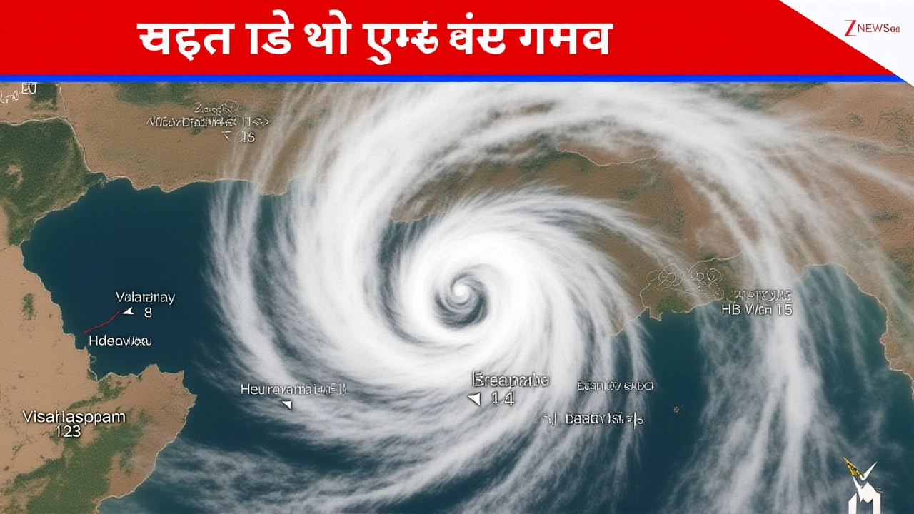
Severe Cyclonic Storm Montha tore across the Andhra Pradesh coastline between Machilipatnam and Kalingapatnam at 7:00 PM IST on October 28, 2025, with winds howling at 90–100 km/h and gusts hitting 110 km/h. The storm didn’t just pass through—it obliterated farmland, flooded villages, and left one person dead. What’s staggering isn’t just the damage, but how close it came to being far worse. Thanks to precise forecasts from the India Meteorological Department (IMD), evacuation orders saved lives, even as 43,000 hectares of crops—mostly rice, cotton, and pulses—were wiped out across the state. The storm’s fury was felt from Kakinada to Visakhapatnam, and its ripples stretched as far as Odisha, Chhattisgarh, and even Gujarat.
From Depression to Disaster: The Storm’s Rapid Rise
Montha didn’t arrive out of nowhere. It began as a deep depression over the southeast Bay of Bengal on October 26, 2025. By October 27, it had strengthened into a cyclonic storm, then exploded into a severe cyclonic storm by dawn on the 28th. The IMD tracked its path with eerie accuracy: at 2:30 AM on the 27th, it was 680 km south-southeast of Kakinada. By 2:15 PM on the 28th, it was just 120 km from Machilipatnam, moving steadily at 12 km/h. That predictability was everything. Unlike past storms where forecasts were vague, this one gave officials nearly 48 hours to prepare.
Evacuations, Shelters, and the Race Against Time
Andhra Pradesh’s disaster machinery kicked into overdrive. Revenue and Disaster Management Minister Suresh Pari warned that 15 districts would be hit, with eight facing "very heavy rainfall and strong winds." District collectors activated control rooms. Schools shut. Cyclone shelters—some built after the 2019 Cyclone Fani—were inspected, stocked with food, water, and medical kits. Evacuations focused on the most vulnerable: pregnant women, the elderly, children, and those living near low-lying coastal zones. In Uppada, Deputy Inspector General of Police Ashok Kumar personally toured the beach road—already destroyed by wind and surge—urging residents to stay indoors. "It’s not a warning," he told reporters. "It’s a command."
Railways, Roads, and the Logistics of Recovery
While people huddled indoors, the wheels of recovery began turning. Railway Minister Ashwini Vaishnaw ordered East Coast Railway and South-Central Railway zones to stand by for immediate restoration. Tracks were already submerged in places near Kakinada, and overhead wires snapped. But with teams pre-positioned, officials hoped to restore partial service within 72 hours. Meanwhile, state engineers surveyed collapsed bridges and washed-out roads. The damage to infrastructure was severe—but not catastrophic. That’s the difference between last-minute panic and coordinated action.

Agricultural Catastrophe: The Silent Toll
The real tragedy lies beneath the floodwaters. The India Meteorological Department confirmed that Nellore district recorded the highest rainfall—over 30 cm in 24 hours. That’s more than half the annual average for some villages. Farmers had just harvested their second rice crop of the year. Now, 43,000 hectares of standing crops are ruined. That’s enough food to feed over 2 million people for a month. Insurance claims will take months to process. Many smallholders won’t recover. "We lost everything," said farmer Ramesh Reddy from Kakinada’s outskirts. "The seedlings were two weeks from harvest. Now it’s mud and rot."
Odisha Escapes, But Just Barely
While Andhra Pradesh reeled, Odisha—a state that’s been battered by cyclones for decades—emerged relatively unscathed. Chief Minister Mohan Charan Majhi credited the state’s "iron-clad preparedness." ODRAF and NDRF teams were deployed across 14 districts. Emergency shelters housed over 80,000 people. No fatalities were reported. "We didn’t get the direct hit," Majhi said. "But we treated it like we did. That’s how you survive."

What Comes Next? Rain, Recovery, and Resilience
The IMD forecasted continued heavy rainfall through October 29, with isolated areas seeing over 20 cm. Coastal Andhra Pradesh and Yanam remain under alert. Power outages affected 1.2 million households. Mobile networks are down in 17 blocks. Recovery won’t be quick. The state government has pledged ₹1,200 crore in immediate relief, with ₹800 crore earmarked for crop compensation. But experts say the bigger lesson is systemic. Climate models predict more intense cyclones forming faster in the Bay of Bengal. The IMD’s success with Montha proves early warning saves lives. But saving livelihoods? That’s harder.
Why This Storm Matters Beyond Andhra
Montha isn’t just another storm. It’s a stress test for India’s disaster response system. In 2013, Cyclone Phailin killed over 40 people in Odisha. In 2019, Fani claimed 64 lives across eastern India. Montha? One death. That’s not luck. It’s data. It’s coordination. It’s decades of learning. But with sea surface temperatures in the Bay of Bengal rising faster than the global average, future storms will be stronger, faster, and harder to predict. The question isn’t whether another Montha will come. It’s whether we’ll be ready for the next one.
Frequently Asked Questions
How many people were evacuated before Cyclone Montha made landfall?
Authorities evacuated over 220,000 people from coastal Andhra Pradesh and Yanam, with priority given to low-lying areas, islands, and vulnerable populations. Over 1,100 cyclone shelters were activated across 15 districts, housing families with food, water, and medical aid. The scale of evacuation was among the largest in India’s recent cyclone history, and officials credit it with preventing mass casualties.
Which crops were most affected by Cyclone Montha’s damage?
Rice was the hardest hit, accounting for nearly 60% of the 43,000 hectares damaged, followed by cotton (20%) and pulses like red gram and black gram (15%). Many of these crops were in their final growth stages, just weeks from harvest. The loss represents an estimated ₹1,800 crore in agricultural output, severely impacting thousands of smallholder farmers who rely on seasonal yields for income and food security.
Why was the India Meteorological Department’s forecast so accurate this time?
The IMD used upgraded satellite data from INSAT-3DR and a new high-resolution weather model called IMD-HighRes, which improved prediction accuracy for rapid intensification events. Combined with real-time buoy readings and drone-based wind measurements over the Bay of Bengal, forecasters could track Montha’s explosive growth with unprecedented precision—giving authorities nearly 48 hours to prepare, compared to just 24 hours for storms in 2018.
What’s being done to help farmers recover from the crop losses?
The Andhra Pradesh government has approved ₹800 crore in immediate crop compensation, with ₹20,000 per hectare for verified losses. Seed packets for short-duration crops like millet and groundnut are being distributed to allow replanting before the next monsoon. The state is also partnering with the National Bank for Agriculture and Rural Development (NABARD) to fast-track low-interest loans. However, experts warn that long-term resilience requires better irrigation infrastructure and crop insurance reform.
Is there a risk of another cyclone hitting the region soon?
The IMD has issued a "no immediate threat" bulletin for the next 10 days, but seasonal conditions remain favorable for cyclone formation through November. Sea surface temperatures remain 1.5°C above average in the Bay of Bengal, and wind shear is low. While no new system is forming now, officials are urging coastal communities to remain vigilant. The 2025 cyclone season is already the third most active on record for the region.
How does Cyclone Montha compare to past storms in terms of intensity and impact?
Montha was weaker than Cyclone Fani (2019), which had 200 km/h winds, but its impact was more concentrated on agriculture. Fani caused widespread infrastructure damage across Odisha and West Bengal. Montha’s wind speeds were lower, but its slow movement over Andhra Pradesh led to prolonged rainfall—over 30 cm in Nellore—making it one of the most agriculturally devastating cyclones in the state’s history. The fatality rate was dramatically lower due to better preparedness.